Reveal Team to Present AI-Driven Geospatial Innovation at GWF 2026
From Insight to Impact: Reveal Team Advances AI-Driven Geospatial Innovation at Geospatial World Forum 2026
This April, the Reveal team will take the global stage at the Geospatial World Forum (GWF) in Amsterdam—one of the premier international gatherings of leaders, innovators, and practitioners shaping the future of geospatial intelligence. Bringing together experts from government, industry, academia, and international organizations, GWF serves as a critical platform for exploring how location-based insights and emerging technologies are transforming decision-making worldwide.
At the heart of Reveal’s presence is a collaborative research effort led by Samuel Alter, whose work reflects the broader innovation and technical depth of the Reveal team. The presentation, “Beyond the Façade: Using Façade-View Imagery and Deep Learning to Predict Likelihood of Demolition,” highlights how we are pushing the boundaries of computer vision and spatial data science to solve complex, real-world challenges.
This work introduces a novel, team-driven approach to understanding the built environment through facade-level imagery. By combining deep learning techniques with geospatial data, the Reveal team has developed an experimental model to estimate the demolition risk of residential properties. This capability directly supports survey address validation efforts—automating a critical step in the pre-survey process typically used by National Statistical Organizations like the U.S. Census Bureau by identifying housing units likely to be removed due to demolition within a defined time horizon before finalization of an address-based sample. The result is a more efficient, scalable, and accurate alternative to traditionally manual workflows and can help avoid nonresponse cases.
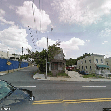
This sequence of Google Street View images from 2007 to 2022 shows an abandoned residence in the Baltimore, Maryland area as it progressively decays and eventually gets demolished in April 2022.
The project integrates diverse datasets, including demolition records, Google Street View imagery, OpenStreetMap data, and municipal parcel information. Through this fusion, the team trains a deep learning model to detect and segment building façades, analyzing both structural and contextual features to predict demolition likelihood within a 48-month window. This approach demonstrates how Reveal’s multidisciplinary expertise—spanning data engineering, machine learning, and geospatial analytics—can unlock new applications for AI in environments where traditional data collection is limited or costly.
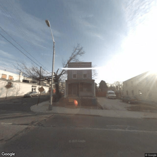
The overlay on this now-demolished Baltimore, Maryland residence shows our trained image segmentation model's mask on the facade (red) and lot (green). The image segmentation model was trained on human-drawn facade and lot masks. This Google Street View image is from August 2009 and the residence was demolished in April 2022.
Beyond its immediate use case, the implications of this work extend far beyond Census Bureau operations. Reveal’s approach establishes a scalable framework for remote building intelligence that can support a wide range of stakeholders from urban planners and municipal agencies to real estate professionals and community organizations. By enabling more proactive, data-driven decision-making, this work has the potential to inform urban development strategies, infrastructure planning, housing policy, and neighborhood revitalization efforts.
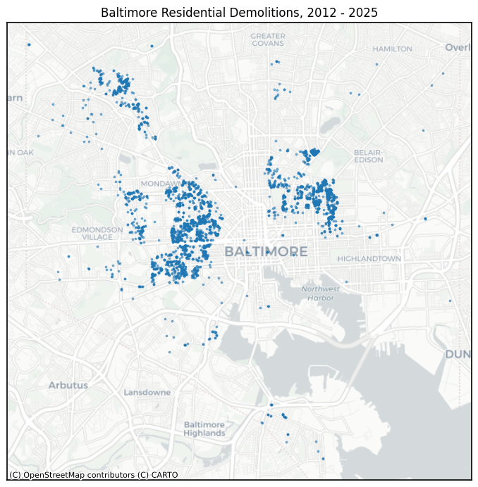
The map shown here is of residential demolitions in Baltimore, Maryland. The data was downloaded from their respective municipal websites and acted as the source information for the addresses and demolition records that we used when collecting Google Street View images of those now-demolished residences. No data from residences that remain occupied and standing were used in this project.
Looking ahead, the Reveal team is actively exploring ways to expand and refine this capability. Future enhancements include extending geographic coverage, improving prediction accuracy across shorter time horizons (24, 12, and 6 months), and enriching outputs with additional insights such as property classification, dwelling unit estimates, and deeper building-level characteristics. These advancements aim to provide a more comprehensive view of housing dynamics, including patterns of occupancy, new construction, and early indicators of residential decline.
As geospatial technologies continue to evolve, this work underscores the power of combining artificial intelligence, imagery, and spatial analytics, as well as the strength of collaborative innovation. Reveal’s presence at GWF 2026 reflects not just a single project, but a team-wide commitment to delivering data-driven solutions that address complex challenges with precision, scalability, and meaningful impact.
Interested in learning more about our work? Connect with us! office@revealgc.com