
Reveal Perspective: Connecting Data for Disaster Preparedness
At Reveal, we believe our work is most meaningful when it helps people better understand the systems that shape their lives. Reveal Perspectives offers a space for our team to reflect on the experiences and values that inform how we approach that work. In this perspective, senior advisor Chip Walker shares his thoughts on the importance of connected data, collaboration, and accessible tools in strengthening disaster preparedness and supporting more informed decision-making.
Building What Counts: Connecting Data for Disaster Preparedness
By Chip Walker
As the 2026 Atlantic hurricane season begins, federal agencies, state and local governments, and volunteer organizations stand ready to respond should a storm impact communities across the United States or its territories. One thing has become increasingly clear to me: effective emergency management depends on collaboration.
My perspective comes from nearly two decades of consulting with the U.S. Census Bureau and speaking with data users across government and public service organizations. Again and again, I heard a similar frustration: people often knew data existed but struggled to easily access it or connect it with other critical information.
Before going further, I think it’s important to acknowledge a foundational principle in any public data conversation: protecting the privacy of individuals, households, and businesses must always come first.
Still, I’m encouraged by the progress being made.
After Hurricane Katrina, I became deeply interested in how data could support emergency management efforts before, during, and after disasters. Working alongside passionate Census Bureau staff, we explored how data tools could make information more accessible and actionable for people making decisions under pressure.
What I’ve learned is that the challenge is rarely a lack of data. Federal agencies already maintain enormous amounts of information that can support preparedness, response, and recovery efforts. The challenge is helping people access and understand that information quickly enough for it to be useful.
That’s where collaboration between agencies becomes so important.
No single agency owns the full picture during an emergency event. Emergency management relies on information coming together from many different places. When those systems remain disconnected, it becomes harder for decision-makers and communities to fully understand what’s happening on the ground.
I’ve become passionate about building tools and experiences that make that information easier to connect, visualize, and use.
One example is the growing use of user-friendly mapping and geospatial tools that surface publicly available data in more intuitive ways. While APIs and advanced technical platforms are valuable, not every user has the expertise to work directly with raw data systems.
Tools like My Community Explorer, built using Esri technology and Census Bureau data, demonstrate how integrated information can help users better understand communities that may be impacted by emergency events.

U.S. Census Bureau My Community Explorer (MCE) 4.6
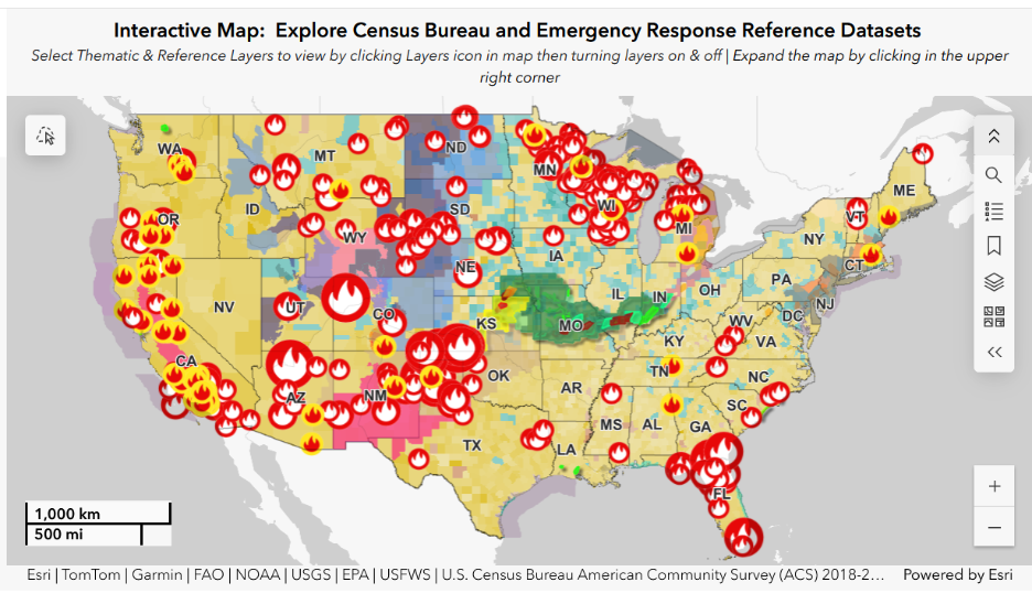
Image Source: U.S. Census Bureau My Community Explorer (MCE), powered by Esri. Dashboard view captured May 18, 2026.
By combining emergency alerts with curated demographic and economic data, users can gain a clearer picture of the people and businesses potentially affected in a geographic area.
In practice, that kind of connected data environment could help agencies quickly understand not just where a hurricane may make landfall, but who may be most impacted. For example, information from the National Oceanic and Atmospheric Administration (NOAA) could help local officials track storm paths, flooding risks, and severe weather conditions, while Federal Emergency Management Agency (FEMA) data could support response coordination and resource planning. Census Bureau data can help identify vulnerable populations, including elderly communities, language access needs, and areas with higher poverty rates, while Environmental Protection Agency (EPA) data may help agencies understand environmental impacts such as air quality concerns following wildfires or industrial disruptions. When these data sources can be viewed together in a more accessible way, decision-makers are better positioned to coordinate resources, communicate clearly, and respond more effectively to community needs.
To me, the most exciting part of this evolution is not simply the technology itself. It’s the opportunity to create stronger connections between agencies, platforms, and public data resources in ways that improve how constituents experience government services.
We’re also seeing promising examples of connecting data tools together to create more seamless user experiences. One example is the ability to move directly from My Community Explorer into a more detailed Census Business Builder report for a selected community using connected tools powered by Esri technology and Census Bureau data resources.
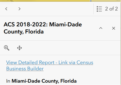
Image Source: U.S. Census Bureau Census Business Builder integrated with My Community Explorer (MCE).
When systems communicate effectively, users spend less time searching for information and more time understanding what actions may be needed. That kind of connected experience can support faster decision-making and coordination across organizations.
Looking ahead, I believe AI presents a major opportunity to help users navigate the growing ecosystem of publicly available government data and connect the information most relevant to the challenges they’re trying to solve.
One of the reasons I’ve remained passionate about this work is the opportunity at Reveal to continue exploring how data, collaboration, and technology can support public sector missions. What I value most is a shared belief that innovation should stay connected to purpose — helping agencies better serve the people and communities relying on them.
That mindset is especially important in emergency management and public service work, where information can support action and coordination when it matters most. At the end of the day, this work is about more than data or technology. It’s about building what counts.
That means building systems, partnerships, and tools that help agencies work together more effectively, improve public understanding, and better support the communities relying on them when it matters most.
## #
To learn more about Reveal’s work supporting data users across government and public service organizations, contact office@revealgc.com